PAPER 2009_HALL_INDONESIA ISLAND
بِسْمِ اللَّهِ الرَّحْمَنِ الرَّحِيمِ
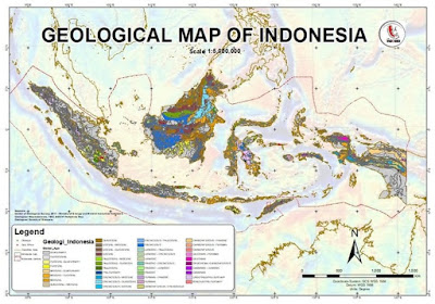
Indonesia is a geologically complex region situated at thesoutheastern edge of the Eurasian continent. It is bordered by tectonically active zones characterized by intense seismicity and volcanism resulting from subduction. Western Indonesia is largely underlain by continental crust, but in eastern Indonesia there is more arc and ophiolitic crust, and several young ocean basins. The Indonesian archipelago formed over the past 300 million years by reassembly of fragments rifted from the Gondwana supercontinent that arrived at the Eurasian subduction margin. The present-day geology of Indonesia is broadly the result of Cenozoic subduction and collision at this margin.
PRESENT-DAY TECTONIC SETTING
Indonesia is an immense archipelago of more than 18,000 islands extending over 5000 km from east to west between 95° and 141° E, and crossing the equator from 6° N to 11° S (Figs. 1 and 2). It is situated at the boundaries of three major plates: Eurasia, India-Australia, and Pacifi c-Philippine Sea. In western Indonesia, the boundary between the Eurasian and Indian plates is the Sunda Trench. Parallel to this in Sumatra is the right-lateral strike-slip Sumatran Fault, which results from the partitioning of oblique plate convergence into normal convergence at the trench and trench-parallel movement further north. Most active deformation in Sumatra occurs between the trench and the
Sumatran fault. In contrast, east of Java, active deformation occurs within a complex suture zone up to 2000 km wide, including several small plates and multiple subduction zones; plate boundaries (Fig. 1) are trenches and another major strike-slip zone, the left-lateral Sorong Fault, which runs from New Guinea into Sulawesi. Global Positioning System (GPS) measurements indicate very high rates of relative motions, typically more than several centimeters per year, between tectonic blocks in Indonesia.

KLIK "DOWNLOAD" NOW


Comments
Post a Comment